|
|
| Walk number 15 |
|
|
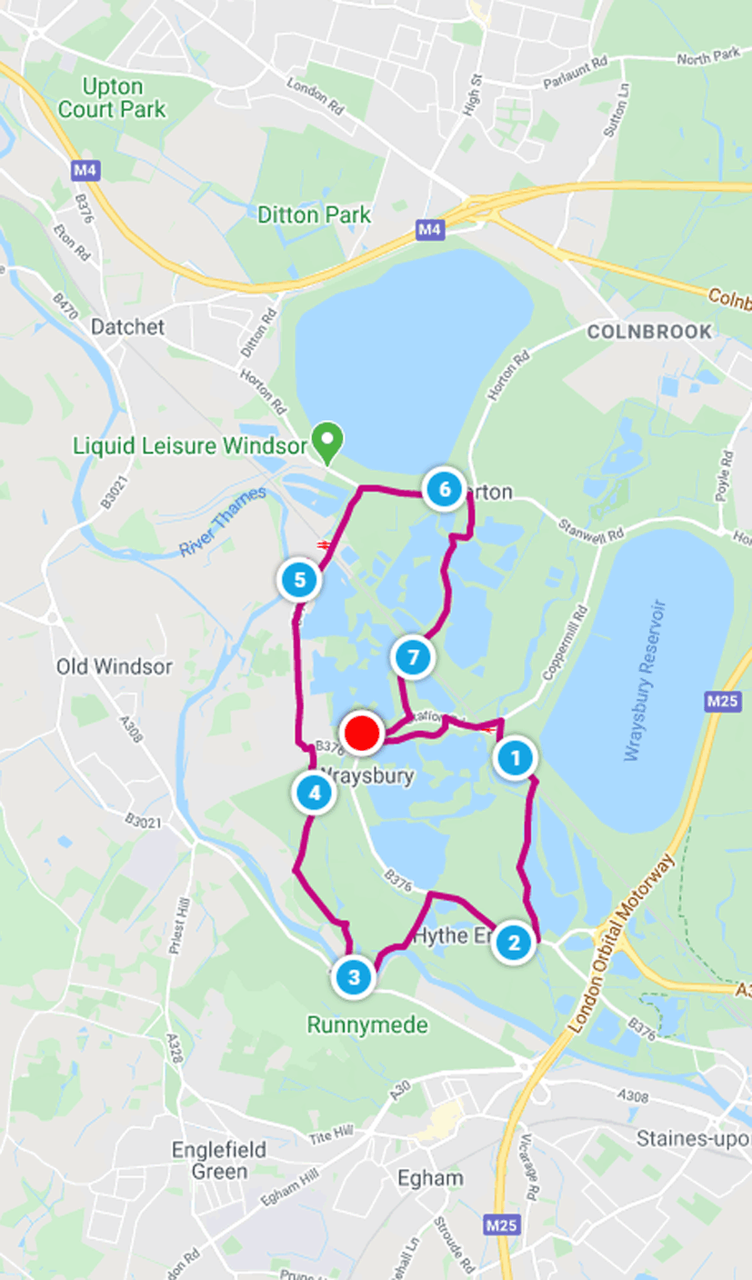
Wraysbury Lakes and Horton (7.55 miles / 12.14 km / 3.75 hours):
|


 |
| Photos copyright © Graham Pearcey 2011 |
|
Please click here for a map of the route.
|
- Use the large public car park on The Green, Wraysbury, Staines, opposite the village hall but alongside Wraysbury Bowls Club, TW19 5NA.
- Leaving the car park where you drove in (with the old windmill now to your right), turn immediate right and reach High Street via a footbridge. Turn right again and cross the street but, almost opposite the Wraysbury Hub (a former church), go through a squeeze stile onto a signed path on your left. Follow this without digression, keeping the backs of houses and gardens to your left, to the weatherboard barns by Tithe Farm. Turn left into Tithe Lane and right when the Lane reaches Station Road. Wraysbury station is ahead.
- Ignoring Wraysbury station approach road take the pavement that ascends to cross the railway line and descends on the other side. At the vehicular entrance to the station car park, carefully cross the road to the bus stop sign and turn right to cross over Colne Brook via a bridge, as you do so noting a very photogenic cottage sitting beyond the Brook and trees to your left. Immediately after this bridge, take the Colnbrook Walk signed to your right.
- This path, sometimes waterlogged and sometimes overgrown with nettles in places, initially crosses a bridge to follow Colne Brook before running parallel to the railway and eventually reaching a Public Footpath sign to the right. Take this and, having carefully crossed the railway tracks by way of two new stiles, bear first left and then right following the marker post and yellow arrow.
- Follow this path with the stream on your right and the lake to your left for three-quarters of a mile to reach a bench, erected by Groundwork to provide views downstream. Soon after the bench you pass an information board explaining about Wraysbury Lakes and climb the steps opposite the MOT Test Centre
- Turn right onto Wraysbury Road, which becomes Staines Road, but dont cross it. When the pavement ends, cross Staines Road with care to continue along the pavement on the left hand side. When this pavement ends, cross back and continue on the right hand side. Arrive at the gates to the Silver Wing Sailing Club.
- Shortly after these gates, cross the road and take the Permitted Footpath to the right of house number 104. Enter Ankerwycke parkland and follow the path.
- Just before the River Thames is reached, go through two kissing gates and then turn right. Keep on the riverside path for some time, ignoring all side paths on your right, until shortly after crossing a small footbridge you find you are walking parallel to a busy road on the far side of the Thames. Emerge through a kissing gate into a meadow. Continue straight ahead towards a kissing gate and field gate in the next corner of this meadow, but do NOT pass through these gates. Instead, bear right at the last moment to pass through another kissing gate alongside another field gate, proceeding along a shady avenue to the ruins of the 12th-century St. Marys Priory.
- Maintain direction and just beyond, on the right, is a sign marking the Ankerwycke Yew, reputedly more than 2,000 years old and designated by the Tree Council as one of fifty Great British Trees in 2002.
- When you are ready to move on, continue on the original path for about 90m, but before the path crosses a bridge follow a narrow unsigned path left to a kissing gate. Enter the field and then cross the concrete bridge into the second field on your right, where there is another kissing gate and a National Trust marker. Bear left onto the track that runs the length of this field, (early on looking upwards over your left shoulder to see the RAF memorial). Eventually houses come into view in Mede Close. You have reached the half-way point of the walk.
- Leave by the gate. Cross Magna Carta Lane to follow the footpath sign to the right of these houses, through another gate. Cross this field towards a further gate on a bridge. Reaching this, go through it. Then, aiming for the spire of St. Andrews Church in the distance, pass through four more kissing gates, the last of which takes you into the churchyard. Keep the church on your left hand side as you proceed to the lych gate and emerge into St. Andrews Close. Walk to the other end of the Close, where you turn left.
- Pass to the right of the large Wraysbury village sign to cut the corner, but then cross to the left hand pavement because this continues throughout the 20mph, 30mph and 40mph sections of Welley Road. When this pavement ends, turn left into The Avenue (signed Public Footpath), then right into Acacia Avenue (signed Sunnymeads Railway Station), then almost immediately right again into Welley Avenue. On returning to Welley Road, turn left to cross the railway. Studs in the road then guide pedestrians over to the right hand pavement.
- At the roundabout turn right (signed Horton) and after some time, as you enter the village, take the first turning on the right: Park Lane. This lane subsequently bears right alongside Lakeside Cottage and then, at the end, you turn left onto a clear footpath. The route crosses a footbridge then proceeds straight ahead to follow a sometimes muddy path, with initially a stream on its left, which eventually passes a closed green gate on your left.
- Maintain direction along the service track, all the way to the end, a T-junction. Now locate a slightly obscure new gate to your left. Take this and a second new gate to (carefully) cross the railway tracks. A new fence to your right now guides you all the way to a swing gate, whence you proceed along a residential road called Douglas Lane.
- At the T-junction with Station Road, turn right, follow the pavement, and turn right again just before The Perseverance pub to retrace your steps to your car.
|
|
This route was last walked on 27 May 2024. Please note that details were accurate as of 2024, but have not been kept up to date since then.
|
|
Return to my Surrey walks page.
|
|


