|
|
| Walk number 8 |
|
|
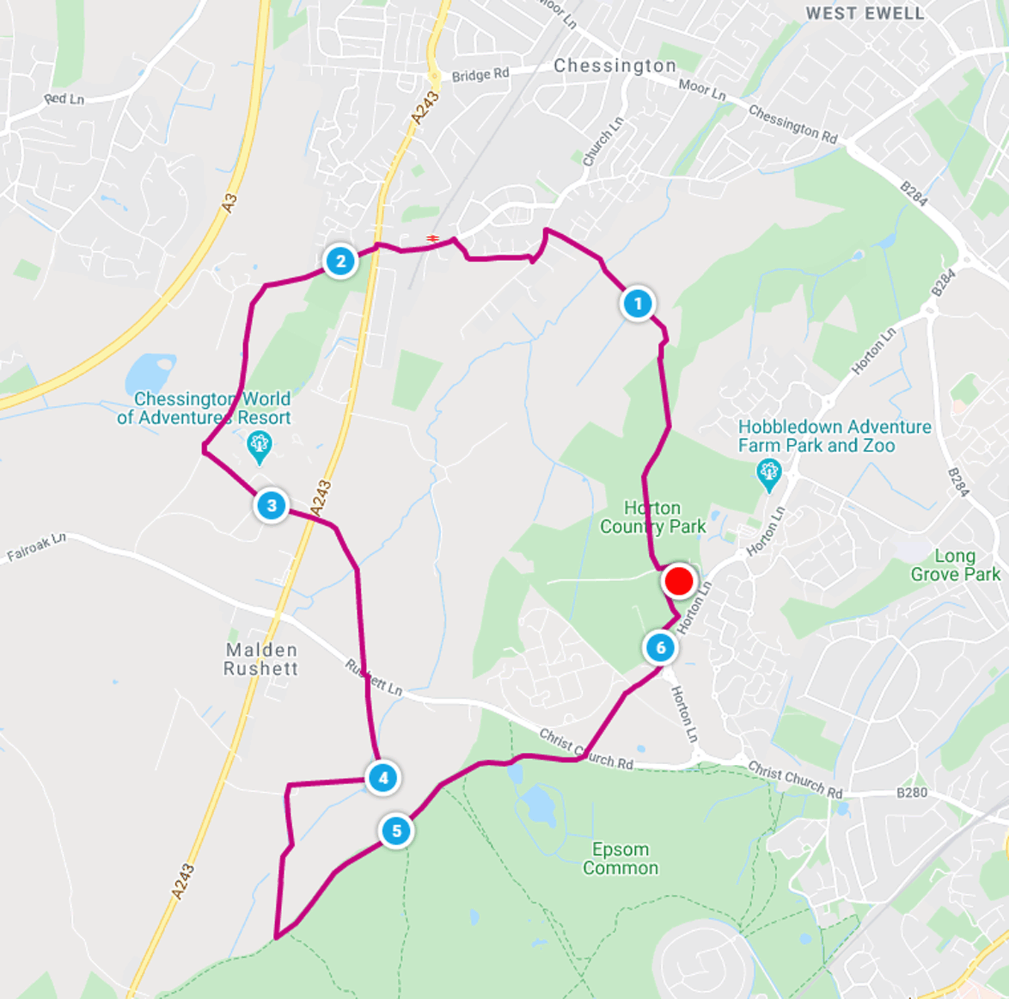
Chessington South and Ashtead Common (6.28 miles / 10.11 km / 3.00 hours):
|


 |
| Photos copyright © Graham Pearcey 2011 & 2012 |
|
Please click here for a map of the route.
|
- Use the Horton Country Park car park off Horton Lane, Epsom, signed Equestrian Centre, KT19 8PL.
- On the road behind the WC, pass the Equestrian Centre (to your right), then turn right immediately after Primrose Cottage, signed Chessington. Pass the Polo Club Car Park, then look left over your shoulder to see the old West Park Hospital Water Tower.
- Ignore side turnings until a major junction, where you fork left, signed Chessington as opposed to Chessington Road. Reach a T-junction and go straight ahead to cross a stile, alongside a kissing gate, into a field. Turn right and follow the field edge, maintaining direction to proceed into a second field. Pass a pylon and, from the next corner of the field, cross Bonesgate Stream via a footbridge. You may hear barking dogs in Star Boarding Kennels to your left. Pass the backs of houses (on your right) en route to Green Lane.
- At Green Lane turn left. Remain on the left-hand pavement as it proceeds behind trees, but cross the road just before the Star Boarding Kennels to arrive at the bottom of steps (signed Public Footpath Garrison Lane). Climb the steps. The path between the old golf course (left) and houses (right) may be muddy. When forced to do so, bear right alongside a padlocked gate and descend to Garrison Lane. Turn left without crossing the road, and follow the pavement over a railway bridge. Where the pavement forks, take the left fork.
- Carefully cross Kingston Road into Barwell Lane. Proceed some distance but, after passing Chessington (gas) Pressure Reducing Installation (right), look out for a gate opposite Virginia Cottage. Proceed through this gate, climb Winey Hill which may be muddy and, on reaching the last of three large conifers, bear slightly right to reach a grassy meadow. Follow the well-worn path to a tree stump visible to your left, then maintain direction to pass a viewpoint (dated 1995) and small pond on your right. The grassy area is then channelled between a hedge and two fences (left) and a woody area (right). The track narrows, becomes muddy, and reaches a very muddy kissing gate next to a field gate. Proceed through the kissing gate.
- Follow the often muddy path between a short fence (right) and the high security fence of Chessington World of Adventures (CWA) on your left. When invited to do so, go left signed Public Footpath Leatherhead Road, then turn left onto a wide pavement between the CWA fence and the road. Pass the main pedestrian entrance to CWA.
- Arriving at a T-junction, you go straight ahead through grasses to follow a wide grassy Public Footpath to Leatherhead Road. Cross and pick up a bridleway signed Ashtead Common that may be badly flooded early on. You have reached the half way point of the walk.
- After some time you approach the busy Rushett Lane. Bear right, cross Rushett Lane carefully, turn left along the pavement and then right through a metal gate onto a bridleway (the gate and sign may be obscured). Bear left in the direction indicated by the Ashtead Common sign, heading towards the tree line where you pass through a gap in the hedge and aim for a signpost clearly visible in the middle of an open space. At this, you turn right (signed Leatherhead Road). After passing through another gap in the hedge, head towards the farm. Proceed through the farm complex, beyond which you go left (signed Leatherhead Road) then straight ahead (signed Ashtead Common) past the barn.
- When the mud track bears right, you proceed straight ahead on grass (sometimes wet) and head towards the tree line where at the last minute you spot a very muddy stile and cross it. To your right is a Type 1 cast iron coal and wine tax post, erected by the City of London in the 19th Century. Turn left. Proceed for some time without digression, with common land to your left and forest to your right. At a cross-paths, where you can see a second tax post to your left, proceed straight ahead (signed Epsom Common). At the next cross-paths proceed straight ahead again (signed Public Bridleway) and after passing a third tax post (right) reach a third cross-paths. Proceed straight ahead again (signed Stamford Green). Passing Stew Pond on your right, continue ahead on the main path (signed Winter Horseride), subsequently forking left to Christchurch Road.
- Cross the road to join a bridleway signed Horton Lane. Maintain direction at the entrance to West Park and follow the left hand pavement before forking left onto the main road. Here take the first left, signed (cycle) Access to Horton Country Park. Then go hard right through a gap in a fence into a small wood, soon emerging through another gap in a fence to turn right onto a wide track, which bears left. Where the Thames Down Link turns right continue straight ahead and, just after passing a severely damaged totem pole, turn right onto a narrow path through woods to return to your car.
|
|
This route was last walked on 12 April 2024. Please note that details were accurate as of 2024, but have not been kept up to date since then.
|
|
Return to my Surrey walks page.
|
|


