|
|
| Walk number 5 |
|
|
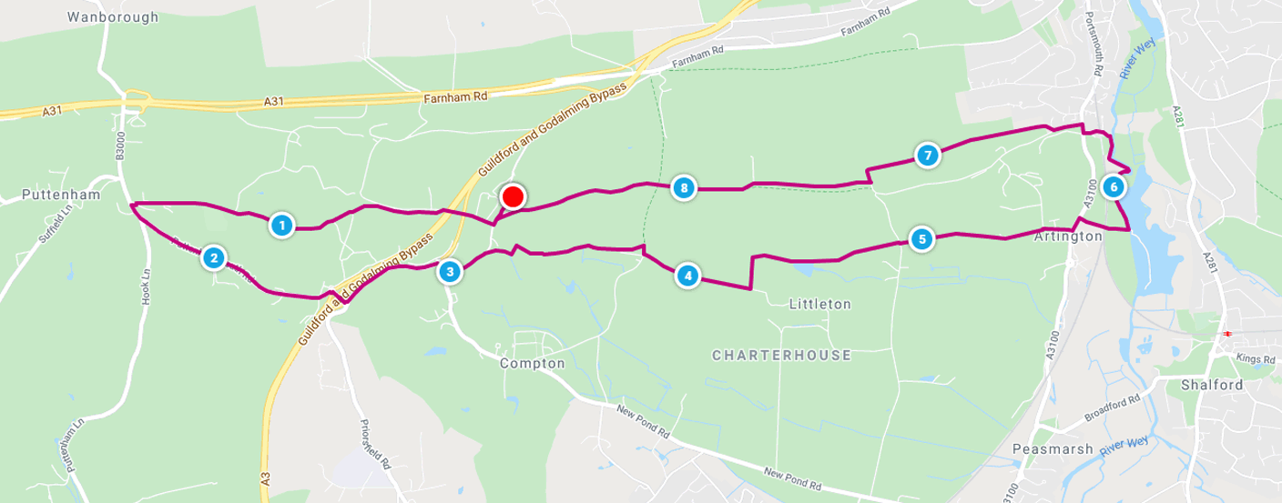
Compton and the River Wey (8.82 miles / 14.20 km / 4.00 hours):
|


 |
| Photos copyright © Graham Pearcey 2012 |
|
Please click here for a map of the route.
|
- Use the car park off Down Lane, Compton, Guildford, behind the Watts Gallery, GU3 1DQ. If the Watts Gallery entrance gate is closed follow signs to the Limnerslease (Studios) car park.
- From the pond alongside the Watts Gallery entrance gate carefully cross Down Lane before taking the first turning on the right, signed Studios. The track proceeds under a brick bridge and then a concrete bridge, but then you take an immediate left, signed Puttenham and North Downs Way (NDW). Continue straight ahead through woods, and follow NDW signs at a staggered junction of footpaths. The path becomes a road, with houses to your right. Ignore all bridleways, etc., to your left keeping ahead through Puttenham Golf Club grounds. After another half a mile, you pass the clubhouse and emerge onto the B3000 opposite the Pickled Pig. Turn left and proceed for a full mile to a roundabout. Just before this roundabout, cross the current road carefully to the pavement on the other side, then cross the A3 by means of a road bridge to reach a second roundabout. Now follow the Compton sign left. Keep to the safe pavement on the left hand side of the road, but note that when the pavement appears to continue at the foot of a grassy bank this actually leads to a dead end, so you need to cross the current road to the right hand side here. At a third roundabout turn right into The Street, and beyond the bus shelter turn immediate left into Down Lane. Take care on this road as theres no pavement.
- Pass the Watts Cemetery Chapel on your right. This is worth a visit.
- When you are ready to move on, continue along Down Lane but shortly follow a public footpath sign (right) through newly fenced fields just before Coneycroft Farm. At a concrete driveway turn right to proceed along its full length to a gate that may be open or closed.
- But turn right again before this gate, then immediate left through a new gate. Keeping between a hedge (left) and fence (right), you reach an old wooden gate whence the footpath continues along a narrow path bounded on both sides by wire fences. The path may be overgrown as you pass houses on your right. Carefully descend steep steps, then turn right. In about 40m reach a junction and turn left to pass through the gate if it is open, otherwise passing to the right of it. Continue along this track and pass a lodge on your left.
- When you reach a field gate signed private (with a warning about CCTV surveillance), turn left onto a footpath around the edge of the Loseley Park grounds. If this is overgrown, switch onto the wider track to your left. At a staggered junction, cross a track and new stile, keeping right through the next field.
- Pass through a black swing gate where the ground can be extremely muddy. Keep the pond to your right en route to an identical gate. Go through this gate and straight ahead across a field (to the right of a new fence). You have reached the half-way point of the walk.
- Pass through a third such gate, then cross another field to pass through the fourth and last such gate. Keep straight ahead at the crossroads alongside Pillarbox Cottage, continuing past bungalows and two cattle grids on your right. Maintain direction onto a grassy uphill track. At the top, continue straight ahead to pass Surrey Police H.Q. (Mount Browne) on your left. Emerge onto a road (it may be very muddy here) and keep straight on to the junction with the A3100. Turn left and, at the bus stop, cross the road to a footpath beyond a barrier. Take this footpath, which proceeds under a railway arch to reach the River Wey.
- Turn left, signed Guildford, and proceed along the towpath. Eventually a river bridge comes into sight.
- Pass under the bridge but then turn sharp left next to a stone seat (it may be very muddy here) onto a steep lane, to pass Ferry Cottage and Pilgrim Cottage on your right. Cross a railway bridge and proceed until Ferry Lane emerges opposite The University of Law. Turn right and then left into Sandy Lane. After passing the back of two groups of town houses, look for the next turning on the right at Piccards Manor and ignore the tracks off this footpath till you reach Piccards Farm.
- Continue past cottages numbered 97 and 96 on the left and subsequently Piccards Farmhouse on your right, onto the farm road. Turn left then right following the NDW signs into woods. (Enter the gate if it is open, otherwise climb the stile to the right of it.) Follow this track until it sweeps right towards Conduit Farm, but you go left. Ignore the narrow track immediately merging in from your left and the subsequent wider track leading to a gate on your left. Instead, head uphill following the narrow sandy track which takes you through the woods. Keep to the main path with occasional posts and stretches of barbed wire on your left hand side ignoring a gate to the left and a subsequent steep path between trees to the right.
- When you (eventually) reach a crossing with a bridleway, proceed straight ahead (still signed NDW). On reaching farm buildings the track becomes wider and sandier. Keep straight on to pass the Watts Gallery, on your right, and return to the pond on Down Lane. From here retrace your steps to your car.
|
|
This route was last walked on 21 July 2024. Please note that details were accurate as of 2024, but have not been kept up to date since then.
|
|
Return to my Surrey walks page.
|
|


