|
|
| Walk number 4 |
|
|
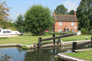
Pyrford Lock and Ripley (8.42 miles / 13.55 km / 3.50 hours):
|


 |
| Photos copyright © Graham Pearcey 2011 & 2012 |
|
Please click here for a map of the route.
|
- Park on The Green, Ripley, Woking, alongside the children's playground, GU23 6AL.
- Proceed along the main tarmac track. (The sign “No Through Road” is intended to deter vehicles not walkers.) Pass The Coach House, farm buildings and Dunsborough Cottages on your left; then swing left with the track. In 130m pass cottages and bear left to follow the recently upgraded footpath that proceeds over two small footbridges to reach Walsham Weir. Do NOT cross the weir but turn left along the towpath with the canal on your right. Continue for 850m to reach Newark Lock.
- Turn right over the Lock footbridge and continue along the canal towpath. The ruins of Newark Priory can be seen across the meadows to your right. On reaching Newark Lane, turn left to cross Newark Mill Bridge by proceeding along the right hand pavement. This becomes a path behind trees that enters a small public car park and continues at the far end. When this path touches the road again, cross carefully to take the safe pavement now to the left of the road, but later cross back to take the third road on your right, Polesden Lane. A sign warns of the lack of a “footway” but the road shouldn’t be too busy. When it draws alongside a lake and public footpath sign to the left, you turn right onto an unmarked path that crosses a stile next to an electricity sub generator. Keep left as this footpath forks away from the main driveway, between two wire fences. On reaching Papercourt Farm turn left onto the road, then right through the farm complex (past “Arts of Steel”), then left through the wrought iron “David’s Gate”, and along a trail. At the end of the trail cross a wooden stile and head across a sometimes muddy field to Papercourt Lock (that was famously moved by the National Trust in order to construct a tiered tumbling bay).
- At the lock, do NOT cross the bridge but follow the sometimes wet towpath, with the canal on your left, back to Newark Mill Bridge.
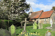
- Cross as before, then proceed along the right hand pavement. When the pavement ends, cross the road with care and continue along the pavement on the other side. Cross Bourne Stream Bridge. When the road bends sharp right in 200m, keep ahead on a rising path to pass St Nicholas Church, Pyrford on your right-hand side. Descend to the road. Proceed along the grass verge in front of Church Farm until the pavement resumes. Continue for 300m. Opposite a Sandy Lane sign, cross the road carefully and proceed straight ahead along the bridleway (not the footpath). On reaching a wooded area turn right over a stile. Proceed with the wood now to your left. You have reached the half way point of the walk.
- Arriving in a field, turn left and proceed towards a tall pylon; but before reaching that turn right to pass through a new small gate alongside a hedge-lined black fence. Keep this hedge/fence on your left till you go through a kissing gate and down the recently renovated driveway to the road, where the timber framed Glebe House dating from the 16th century is to your right.
- Cross the road, going slightly right to enter a gate. Follow the footpath along the fenced-off left-hand edge of a field and over a footbridge to reach a golf course. Proceed straight ahead following footpath marker posts (passing between two pairs of mounds before the third marker). At the fourth marker the yellow arrow directs you to turn left. Head in this direction (left of the lake) till you see a gravel path. At the far end of this path you enter scrubland, where narrow footpaths go both left and straight ahead; go straight ahead but then keep bearing right to eventually reach a road. Turn right at the road to cross a canal bridge alongside Pyrford Lock. Look for a kissing gate to the left of the yellow grit bin ahead of you, and go along this footpath for 400m. To your left, you may catch a glimpse of Wisley Church through the trees.
- Ignore tracks off, left and right; but at the T-junction turn right along the tarmac track, signed as a public footpath, leading towards the Wisley Golf Course clubhouse, 800m away. At the end of a small wooded area, follow the public footpath signs right along a meandering path, with the clubhouse away to your left, and on for another 600m. You catch one view of the RHS Wisley glasshouse to your left early on, and better views of it later. On reaching the wooden pump-house the footpath bears right. Reach the golf-course perimeter and the Wey Navigations towpath. Turn left and continue straight along the towpath for nearly fifteen minutes until you reach the lockkeeper’s house.
- Just past the house turn left to cross the weir and then retrace your steps to Dunsborough Cottages, but this time maintain direction onto the common, taking the middle of three forked paths and heading towards a gap in the distant tree line. Enter the woods alongside an old bench and proceed straight ahead to find a sign announcing a bridleway within the woods. Turn right onto the bridleway, ignoring cross tracks and footpaths, until it narrows and ends with houses in front of you and to your left. Bear right onto a grassy path. Walk to the cricket pavilion and turn left to reach the High Street. Turn right and, when safe to do so, carefully cross the road. As you head towards the centre of the village you pass historic buildings such as Cobham Cottages, The Ship and the One-Stop shop. At the bakery turn left into Rose Lane. Opposite Appletrees, cross the road and locate a public footpath. Access is through an electrically operated security gate. At the farmhouse the footpath turns to the right and through a gate into the eastern end of the churchyard.
- Pass to the left of the church to view the grave of Conor, Eric Clapton’s son, alongside the south wall of the nave. Locate a pathway beyond the church hall that leads back to the High Street. Cross towards The Georgian House and turn right along the pavement. Pass the Manor House and turn left into Newark Lane but cross to take the safe pavement on the right-hand side. Ignore the first roadway on the right leading to Ripley Green, continuing along Newark Lane opposite the Ebenezer Strict Baptist Chapel. Just before the gateway into Dunsborough Park, opposite the entrance to Wentworth Close, double back to your right onto the Green. Keep left and gradually bear left to pass (on your right-hand side) a large hollow (formerly the village pond). On reaching the children’s playground turn right to return to your car.
|
|
This route was last walked on 30 June 2024, and the directions were accurate then. Please e-mail me if you find any errors, or if you would like a copy in Word format, or if you would prefer a version that starts and ends at West Byfleet station (add 3 miles/ 1.25 hours).
|
|
Return to my Surrey walks page.
|
|


